

My Hardiness Zone and How PlantTAGG Works
We are regularly asked how PlantTAGG determines Hardiness Zones for a gardener’s yard. The power of PlantTAGG is deeply rooted in the system’s precise location-based data algorithms. And, our comprehensive expert-crafted plant content is unmatched. When we set out to create PlantTAGG, we were motivated by the realization that gardeners relied upon inaccurate or outdated information. In the best case, a plant’s “instruction manual” is based on where the plant was grown and not where a gardener lives, and in the worst case, the information is just wrong!
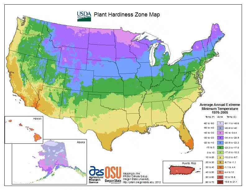
Many gardeners use the USDA Hardiness Zone map. Most garden center owners know this data is outdated. However, gardeners often are surprised to hear that the Hardiness Zone map was published in 2012. Even worse, it contains data only from 1995 to 2006!
Hardiness Zone Calculation in PlantTAGG
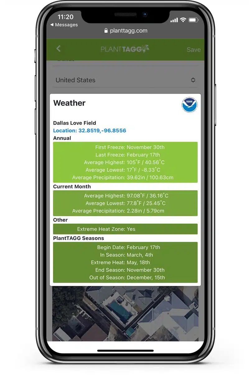
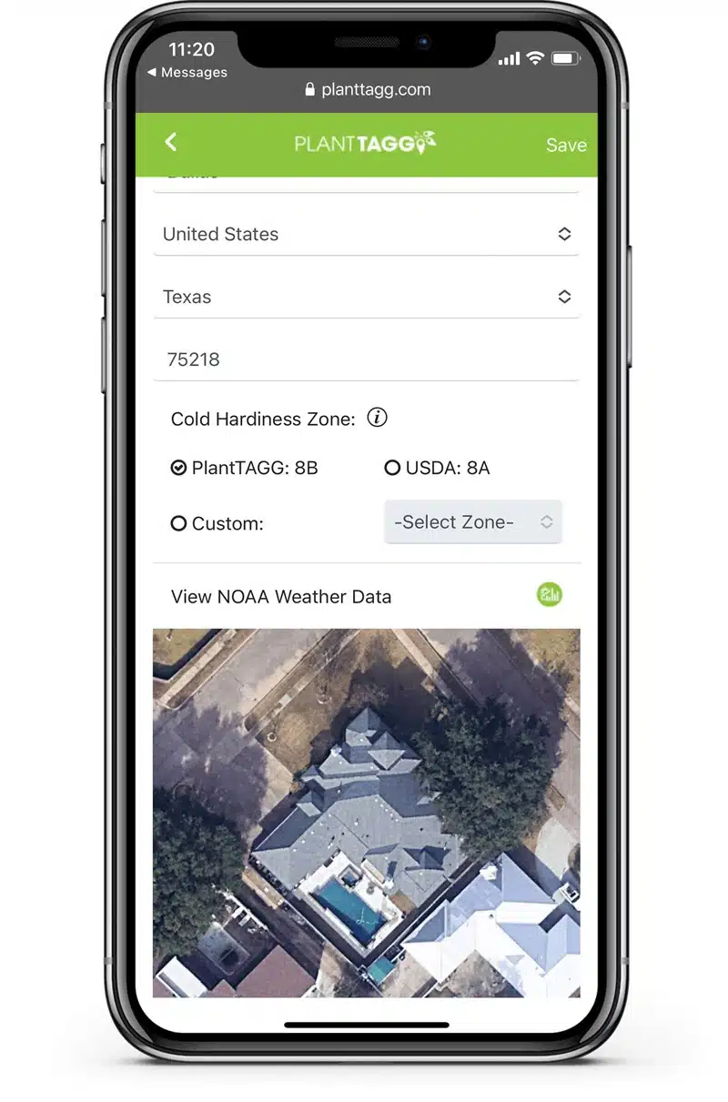
When users first set up their PlantTAGG Yard, the system prompts for a physical address. We determine the precise geo-coordinates from this address and download an aerial image of the property for visual accuracy. Then we access the most current 17 years of climatic data from the closest NOAA weather station. From there, we calculate the PlantTAGG season map for the yard. The season map includes Begin Season, In Season, Extreme Heat (if applicable), End of Season, and Off Season. We base the season map’s start and end dates on the average first and last freeze dates for the yard and year-round climatic data. This process gives us the precision to recommend care tasks unique to each plant in a PlantTAGG Yard.


Comment (1)
I quickly read through this page. It SOUNDS as if you’re recognizing that plants survive/thrive through U.S. winters based on the Lowest temperatures ever or in the past 10-20 years (mincing words and assuming that lowest temperature is for a meaningful time… as in a few hours or more), and that your location analysis might even include humidity. I’m VERY thrilled that you are at least making a Start with revolutionizing the Plant Industry to address local markets and Actual cold hardiness. I hope you are also incorporating specific newer plant varieties which overcome diseases (e.g., powdery mildew!! “Little Goldstar” Ruddbeckia), perhaps it includes Rabbit (!!!) and Deer-resistance, and perhaps modifying the definition of Perennial (2 year survivability) to perhaps a new word, “Long-ennial” (10-20 years) or even to show a range of how long each variety is expected to live (e.g., “Zagreb” Coreopsis verticillata vs. all the other poor-performance Coreopsis). I’ve loaded your app… I’m not a fan of cell phones apps, but it has 2 Great advantages (younger gardeners and ability to bring it to a local nursery)… although I would prefer an online site. If I like the app, I’ll likely give you Lots of feedback… because I LOVE what you’re trying to do (and I’ve drafted a 100-page document about the very topic of Viable Long-ennials in my local climate (75034 TX). Great idea! Thank you for your ingenuity and steps to improve (upgrade & correct!!!) the Plant Industry for us all!